


 |
||
 |
||
|
||
After a number of fields have been completed WAG and the Community Archaeologists will get together to clean and mark the finds each with their unique identifying codes. This gives everybody a chance to view all the finds together and for members of WAG to learn from the experts. News of when these meetings will be posted on the home page of this site. The details of the finds and their locations will be mapped and compared with the results from augering (taking core samples of the deposits). Eventually, all the finds will be deposited in the musem. |
||
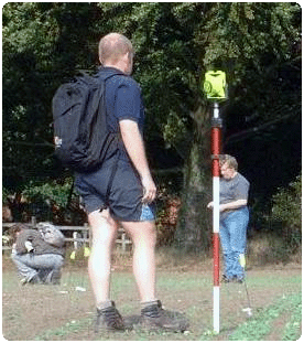
Washingborough Archaeology Group usually conducts its own field walking projects and has covered much of the Washingborough parish over the past 14 years. Matt Vickers (WAG leader) organises the team during a fieldwalk giving us a briefing and de-briefing on each field walk, describing and showing examples of the finds we are looking for and where possible describes what the finds may be. Our technique is very much similar to the above description, but where we lack the technology for precise plotting we rely upon a lower tech approach by alphabetising each 10m transect and recording finds within them. Each find from along a transect is placed into a labelled bag by the fieldwalker, this allows for the types and spreads of finds to be plotted onto graphs and maps to indicate where concentrations of certain finds may be and could hint at the likely activities that were taking place there many years ago. After a field walk we usually get together to clean and label the finds for identification and to discuss what we have discovered. |
||
|
||
| If you are interested in joining in, please do feel free to come along to one of our meetings or contact us via
e-mail or the forum. The more the
merrier! |
||
v.4 'Rise of the Screen' |